 The Process of Our Mapping Program
KRWA will be here to help you develop and implement your mapping to meet future needs of your utilities and your community. The main advantage KRWA guarantees is that you will be in control of your data. You will not find any more reasonable costs for these services.
KRWA is prepared to respond to your interest by providing a pre-assessment. KRWA staff also are pleased to attend a meeting of your board or council to further discuss and demonstrate how you can obtain better quality maps at affordable costs.
Overview
GPS Mapping at Kansas Rural Water consists of two components: data collection and map production. A multitude of methods exist to collect system data, ranging from pencil drawings to digital CAD drawings. The five primary methods that have been investigated in the process of data collection by Kansas Rural Water are:
- manual digitizing
- heads up digitizing over scanned engineering drawings
- heads up digitizing over digital orthophotography with engineering drawing reference
- automated raster/vector conversion
- and field data collection
KRWA has determined that the best process for data development is a combination of two processes: heads up digitizing over digital orthophotography with engineered drawing reference augmented with field data collection.
The data from the field collection is imported over the digital orthophotography. If the scale and projections are correct, the points appear on the aerial just where they are in the real world. The heads up digitizing begins with the placement of non-visible system features, those that could not be field collected, over the aerial. Referring to the engineered drawings aids in the correct placement of features such as line locations and the correct layout of pipeline configurations, such as valve intersections. The field data collection is crucial in that it shows the exact placement of a feature versus a close approximation through the digitizing process.
Getting Started
A city or RWD contacts KRWA expressing an interest in GPS mapping. A KRWA representative will lead the system representative through a short pre-assessment survey to determine what the system needs and how KRWA can best provide that.
After the city or RWD decides to proceed with the GPS mapping, the next step is to collect data. The field data collection involves using GPS equipment to record the coordinates of visible system features (valves, hydrants, meters, trenches, markers, etc.). The accuracy of the equipment used by KRWA is within one foot of actual location of the feature. This means that after a point is collected with KRWA's equipment, it is possible to navigate back to within one foot of that exact position with comparable GPS equipment. One-foot accuracy is very adequate for water and wastewater utilities.
It is essential that the city or RWD participate in the data collection process. Time in the field is minimized and accuracy is increased if the system representative drives the vehicle to the desired locations and the KRWA technician records the data. The system representative knows the system and the KRWA technician is able to do a better job logging the information.
KRWA provides cost estimates for the data collection of a water or wastewater system. The estimated cost is based on the number of features to be data collected. KRWA charges an hourly rate based on the number of points to be collected. If the utility is prepared for data collection by pre-locating and marking all features to be collected, the data collection can be performed more efficiently, thus reducing the overall cost of the project.
Gathering Data
A multitude of methods exist to record system data from pencil drawings to digital CAD drawings. The five primary methods that have been investigated in the process of data collection by Kansas Rural Water are:
- manual digitizing,
- heads up digitizing over scanned engineering drawings,
- heads up digitizing over digital orthophotography with engineering drawing reference,
- automated raster/vector conversion,
- and field data collection.
Manual Digitizing
Manual digitizing with a digitizing tablet has been widely used in the industry. With this method, the operator manually traces all the lines from his hardcopy map using a pointer device and creates an identical digital map on his computer. For example, collecting a series of points along the line digitizes the line. Although this method is straight forward, it requires an experienced operator and is very time consuming. For a complex contour map, it can take a person many days to get the map fully digitized.
Another major drawback of this method is its low accuracy. The accuracy of manual digitizing merely depends on how accurate the hardcopy map is duplicated on a computer by hand. The spatial accuracy level the human hand can resolve is about 40 DPI (dots per inch) in the best case and will be lower while the operator is tired and bored after working on it for a period of time.
Heads-up Digitizing Over Scanned Engineering Drawings
Heads-up digitizing is similar to manual digitizing in the way the lines have to be traced by hand, but it works directly on the computer screen using the scanned raster image (engineering drawing) as backdrop.
While lines are still manually traced, the accuracy level is greater than using digitizing tablet because the raster images are scanned at high resolution, normally from 200 dots per inch (DPI) to 1600 DPI. With the help of the display tools, such as zoom in and out, the operator can actually work with the resolution of the raster data therefore digitize at a higher accuracy level. However, the accuracy level is still not guaranteed because it is highly dependent on the operator and how he digitizes. This method is also time-consuming and takes about same amount of time as the manual digitizing method.
Heads-up Digitizing Over Digital Orthophotography with Engineering Drawing Reference
Heads-up digitizing in this method of data development is similar to the previous method, heads up digitizing over scanned engineering drawings, except that it is done over digital orthophotography with engineering drawings used as a reference.
Automated Raster/Vector Conversion of Scanned Engineering Drawings
Automatic digitizing, or so called automated raster to vector conversion, traces lines automatically from the scanned raster image using image processing and pattern recognition techniques. The idea behind automated raster to vector conversion algorithm is to let the computer do the actual line tracing and eliminate manual tracing performed by the operator.
The automation of the raster to vector conversion process has been a major research focus during the past two decades. Only in recent years has automated raster to vector conversion software on PCs and small computers become practical and commercially available for data acquisition applications. However, fully automatic raster to vector conversion cannot be applied in cases such as low image quality and complex layers.
Field Data Collection
Field data collection is a process of data development where the coordinates of visible system features are collected. The accuracy of the collection equipment is paramount when the features have to be later re-located, such as buried valves. This process in itself, although accurate, does not lend itself readily to map production. An auxiliary system is required in order to make the data more "user friendly".
The Winning Combination
Kansas Rural Water has determined that the best process for data development is a combination of two processes, heads up digitizing over digital orthophotography with engineering drawing reference augmented with field data collection.
The data from the field collection are imported over the digital orthophotography and if the scales and projections are correct, the points appear on the aerial just where they are in the real world. The heads up digitizing begins with the placement of non-visible system features, those that could not be field collected, over the aerial. Referring to the engineering drawing aids in the correct placement of features, such as line location, and the correct layout of interchanges, such as valve intersections.
The field data collection is crucial in that it shows the exact placement of a feature versus a close approximation through the digitizing process.
Other Data Sources
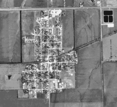 DOQQ example of Benton, Kansas
A secondary source of aerial photography is the United States Department of Agriculture Service Center Initiative, or GeoSpacial Data Gateway. The Geospatial Data Gateway provides Internet-based, one-stop-shopping for natural resource or environmental data. It offers a single access point to a vast store of data, allowing you to browse through what is available, choose only the area that is needed, order it in the desired projection and format, and have it automatically delivered electronically or via CD. The color aerials from this website are also one meter resolution and have better contrast than that of black and white photos as shown above.
 color aerial with 1 meter resolution
The most sought-after resolution for aerial photography to be used as a base layer for printed maps is 6-inch, high resolution. This can be somewhat difficult to come by but when it is acquired, it benefits the utility (city or RWD) by providing better representation of in-the-field conditions.
Below: comparison between 1 meter and 6 inch resolution using the City of Olpe.
 1 meter resolution
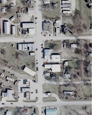 6 inch resolution
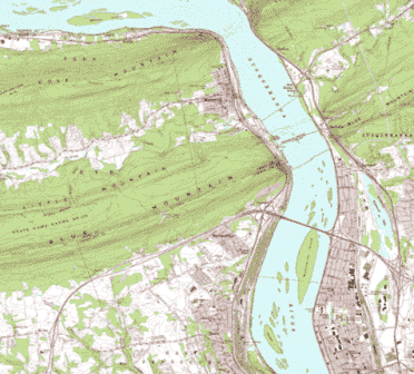 DRG example of Harrisburg, Pennsylvania
Digital Raster Graphic
A digital raster graphic (DRG) is a scanned image of a U.S. Geological Survey (USGS) standard series topographic map, including all map collar information. The graphic portion of the map is geo-referenced to the surface of the earth and fit to the Universal Transverse Mercator projection. The horizontal positional accuracy and datum of the DRG matches the accuracy and datum of the source map. The map is scanned at a minimum resolution of 250 dots per inch. A good source for the DRGs is the US Geological Survey's website.
The DRG's have been found difficult to use for KRWA's GPS mapping purposes. They are scanned and formatted at a 1:24,000 scale and are limited to that scale. The graphic and text "comes apart" when blown to the scale utilized in mapping rural water districts, 1:500.
Equipment Used
There are three grades of data collection equipment: survey grade, mapping grade and commercial grade. The survey grade equipment maintains an average of 1/4-inch accuracy and costs $50,000 to $60,000. The mapping grade equipment maintains an average of 12-18-inch accuracy and costs $5,000 to $15,000. Commercial grade equipment can be purchased at most outdoor supply stores, maintains an accuracy of 30 to 90 feet and costs $75 to $500. KRWA field staff utilizes mapping grade equipment, set up for data collection. KRWA's equipment has an acceptable amount of accuracy for the type of data collection involved.
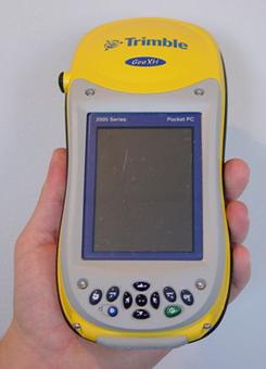 GPS equipment used
KRWA uses the Trimble© GeoXH to collect data in the field. The GeoXH handheld is Trimble's top of-the-line solution for high accuracy GPS data collection. Engineered with H-Star technology, the GeoXH handheld delivers the sub-foot (30 cm) accuracy required by electric and gas utilities, water and wastewater services, land reform projects, and other applications where on-the-spot positioning is crucial.
The unique GeoExplorer series combines a Trimble&cppy; GPS receiver with a rugged handheld computer, built for all-day use.
The GeoXH handheld comes with a powerful 416 MHz processor, running the most advanced operating system available -- Microsoft&cppy; Windows MobileT Version 5.0 software for Pocket PC. Windows Mobile is the industry standard open platform for mobile devices. Windows Mobile Version 5.0 features familiar Microsoft software, including Pocket Word, Pocket Excel, and Pocket Outlook&cppy;. This provides KRWA all the tools needed for a seamless exchange of data between the field and the office. With increased security features and persistent memory storage, you can be sure your data is safe once it's been collected.
Software
KRWA owns several different software packages for the purpose of collecting data and post-processing that data in order to achieve the highest accuracy possible for the most affordable cost. ArcView 9.1 is the package that allows KRWA to create the GIS to the utility's specifications. ArcView allows a technician to include different layers in the creation of the GIS. Aerial photography, parcel IDs, road center lines, streams, boundaries, and any other layers of information that are available can be included in the utility's GIS. Before the layers are 'stacked', the data that was collected in the field is post-processed. This procedure is performed by the software package GPS Analyst/GPS Correct and allows for increased accuracy by contacting known base stations via the Internet and comparing the known coordinates of those base stations and the recently collected data from the field. This post processing reduces the error in data that may have occurred in the field from uncontrollable events such as weather, ionic disruption or satellite signal loss. ArcPad is the software platform that is utilized on the GeoXH in order to interpret and log the data that is being received from the satellites. All of these software packages are necessary to collect and improve the data in order to facilitate the production of the digital GIS and the maps that are printed for the utility.
Generating the Maps
Once the field data collection is complete, the process of creating the maps can begin. There are several items that serve as an aid in the production of the high-quality mapping product. These items include: the collected data, engineering drawings, digital orthophotography, and a mapping application to pull it all together.
The ArcGIS Desktop
The Environmental Systems Research Institute (ESRI) was founded in 1969 at Redlands, California and has become a world leader in Geographic Information Systems (GIS) software. The ArcGIS Desktop is a scalable family of software for geographic data creation, integration and analysis. The ArcGIS Desktop consists of: ArcReader/ArcExplorer, ArcView, ArcEditor, and ArcInfo.
Small utilities that do not want to edit the data that has been collected, but would like to do some simple viewing and printing on their PC can use ArcExplorer. ArcExplorer allows the utility to import different shapefiles and label/re-label features in their system. It also allows for the replacement of outdated shapefiles with current or better ones. For example, if a system/city is photographed with higher resolution photography, those older aerials can be taken out of the existing digital map file and the newer aerials can be imported without re-publishing. There is no charge for ArcExplorer software as it is a viewing software only. It is similar to Adobe Acrobat Reader in that regard.
ArcView will allow a utility to edit or build its own maps. The layers creating the map must be in a shape file format. The shape file is an ESRI file that contains shapes (points, lines, and polygons) and allows for some basic information (attributes) about the shapes. KRWA can provide some simple programming applications to make things easier for the utility. KRWA has used these Visual Basic Applications (VBA) to allow a client system to select a waterline and be able to easily change the diameter, type of pipe, year installed, etc. The cost of ArcView is approximately $1,500 to $2,000.
If it is necessary for the utility to have their information in a geodatabase, they must have ArcEditor or ArcInfo to be able to use the full abilities of a geodatabase. The best reason to use a geodatabase is to be able to use the utility network tools. The utility network tools will allow a user to click on a waterline with a leak and highlight what valves need to be closed to isolate the line. There are certain tracing features to show water flow direction among other things, but the tool used the most by utilities is to highlight valves to isolate a water line.
Most of the small communities do not need these capabilities. In Garden City, KS for example, these capabilities are used, but the city recognizes it has a very complicated distribution system. Cities half the size of Garden City or a population of 15,000 may be able to use these tools, but a town the size of 10,000 or less may not get much use from them. In addition, a high level of software familiarity is essential.
Layers, Themes, and Transparencies
Using the ArcGIS Desktop requires some skill and specialized training. It is similar to a CAD application in that it uses layers (ArcView calls them themes) synchronized to a coordinate system. The themes can be compared to sheets of transparencies. The transparencies can consist of: digital orthophotography, the collected points, sections and section lines, roads and road names, and the digitized or created system features. The themes are stacked and when looking through them all, just as you would a stack of transparencies, it all comes together to create a base map.
Data Modeling
Attributes are information in the database about the feature. Examples are: pipe size, pipe type, and date of installation. These details can be integrated into ArcView with some of the previously mentioned visual basic applications as a "link" to a feature, but to gain the full use of the data ArcInfo is required. Full use is defined as searching, sorting, preparing reports, identification utilities, etc.
The attributes in both cases work best when formatted into a data model. A data model is a simple list of attributes that pertain to each class of feature, classes such as valves, meters, lines, or hydrants. You can create a specialized data model or use an existing data model. When using an existing data model, you only need to use the fields that are relevant to your project.
| Sample Data Model |
| ESRI Data Model - Pressurized Main |
| Administrative Area |
Enabled |
| FacilityID |
InstallDate |
| OperationalArea |
LifeCycleStatus |
| SubType |
WorkOrderID |
| FlowMeasurementID |
WaterType |
| Material |
ExteriorCoating |
| JointType1 |
JointType2 |
| LiningType |
PipeClass |
| Roughness |
Depth |
| Diameter |
GroundSurfaceType |
| PressureRating |
Length |
The End Result
KRWA's map production can generate printed maps and a digital map file. See more about our Mapping Products here. The printed maps can be large-scale wall maps, 42" by 42+", showing the major features with just about any layer desired (aerial photos, streets, sections, railroads, rivers and streams, etc.).
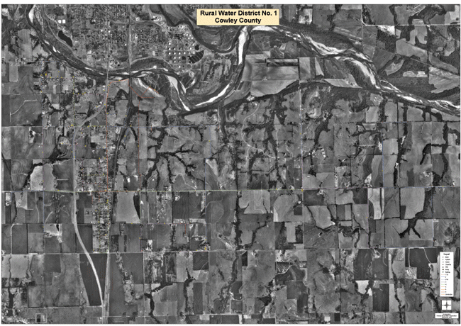
Example of a 42" x 42" Wall Map. This example is RWD No. 1 Cowley County.
The printed maps can also be generated into a map book format. The map book is a bound 18" by 24" book of high-detail maps printed at whatever scale the utility desires. An index of detail sheets is also included. The digital map file can be viewed and printed with free software that KRWA will provide. The software and file can be used on nearly any Pentium-level computer.
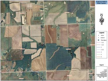
Example of a 18" x 24" map book.
This example is RWD No. 4 Anderson County.
Feature attributes, details such as size and date of installation, can be added and edited with additional programming. The city or RWD can also utilize after-market products such as hand-held computers in conjunction with a GPS attachment in order to navigate in the field. The possibilities are limitless and the costs incurred with developing a Geographic Information System are solely dependent on the needs of the utility and its future intentions.
Sharing Your Data
Kansas Rural Water has adopted the following policy concerning sharing digital data for the purposes of developing a Geographic Information System or creating maps:
KRWA is not the owner of any GIS data that KRWA staff collects or develops. The data (gps positions, feature locations, line representations, shape files, geo-rectified aerial photography and all GIS layers) are the property of the utility that has contracted with KRWA to conduct mapping services. KRWA will share all GIS data that it possesses only upon written approval from the owner. Any request for data should be directed to the KRWA GIS coordinator or to the utility that is represented by the data. Upon receipt of written approval of any request, the data will be sent to the requestor. Fees associated with copying files to media, and/or postage will be the responsibility of the requestor.
Should you share your data?
Sharing data can be of great benefit to many different county and state agencies. Sharing promotes communication and relations between agencies that allow them to better serve the local communities. By allowing several different agencies to utilize your GIS data, more oversight can occur. If more people see and use your data, inconsistencies, inaccuracies, additions, and corrections can be identified and addressed. Sharing also makes the data available to personnel in critical, decision-making positions during times of planning and emergency. In the event of a natural disaster, data can be accessed by emergency management to possibly save lives.
Sharing is a good way of backing-up your data. By allowing others to acquire copies of your data and utilize/store it in an off-site location, you are ensuring its existence in the event that your copies are lost or destroyed.
Sometimes, there are fees associated with sharing data. Fees vary greatly and could be free or cost several thousand dollars. It is difficult to determine what fee to charge for data because the cost to produce it can vary so much. Only a few hours is spent to produce a new shape file that represents water line locations in a very small community. However, to hire a company for high-resolution aerial photography, the cost may be tens of thousands of dollars. A question for a GIS Department or Appraiser’s office to ask might be; “How many times do the taxpayers need to pay for this data?” If high-resolution aerials were paid for out of a county’s general fund, and a request for those aerials comes from a department, agency or some other entity that resides within the tax-base, any money that is paid for the aerials could be considered a “double charge”. The same could be considered for any data layer.
K.S.A 45-219 addresses the issue of reasonable and allowed fees associated with copying records. It also identifies where any fees will be remitted. In all cases, the money will reimburse the general fund of the taxing subdivision.
If you would like to acquire data that KRWA has collected for a Kansas city or rural water district, you may access the system directory for contact information, or you may contact the KRWA for more information.
Statewide opinions about sharing data
The Kansas Collaborative in partnership with the Kansas GIS Policy Board created a GIS discussion forum in 2006 as part of local GIS outreach efforts. The forum can be accessed by submitting questions to the email address: . Any question submitted to this forum will be viewed by Kansas County Appraisers, GIS department personnel, staff in county sheriffs’ offices, GIS Policy Board members, Data Access and Support Center staff and many other people with positions in GIS. There are over 350 people on the GIS List Serve (forum). Folks can also be added to the GIS List Serve by e-mailing Ken Nelson at
KRWA GIS Coordinator Pete Koenig submitted a question about sharing data, specifically, sharing county-owned, high-resolution aerials in exchange for rural water district infrastructure files. Here is a pdf transcript of that email and responses received. See also the Attorney General's response.